Agreed
Back to results
Lands at Ballyhornan Road & Struell Wells Road, Downpatrick, BT30 6RJ
Agreed
File Ref: 9563
Agricultural Lands
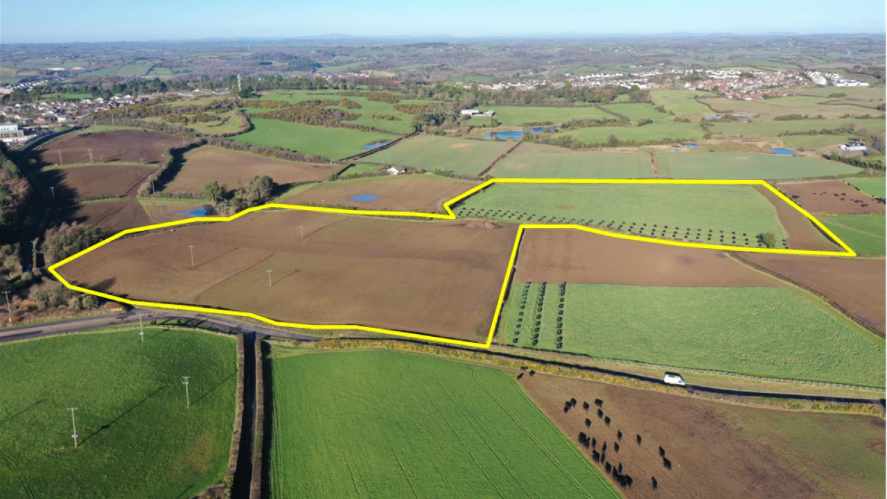
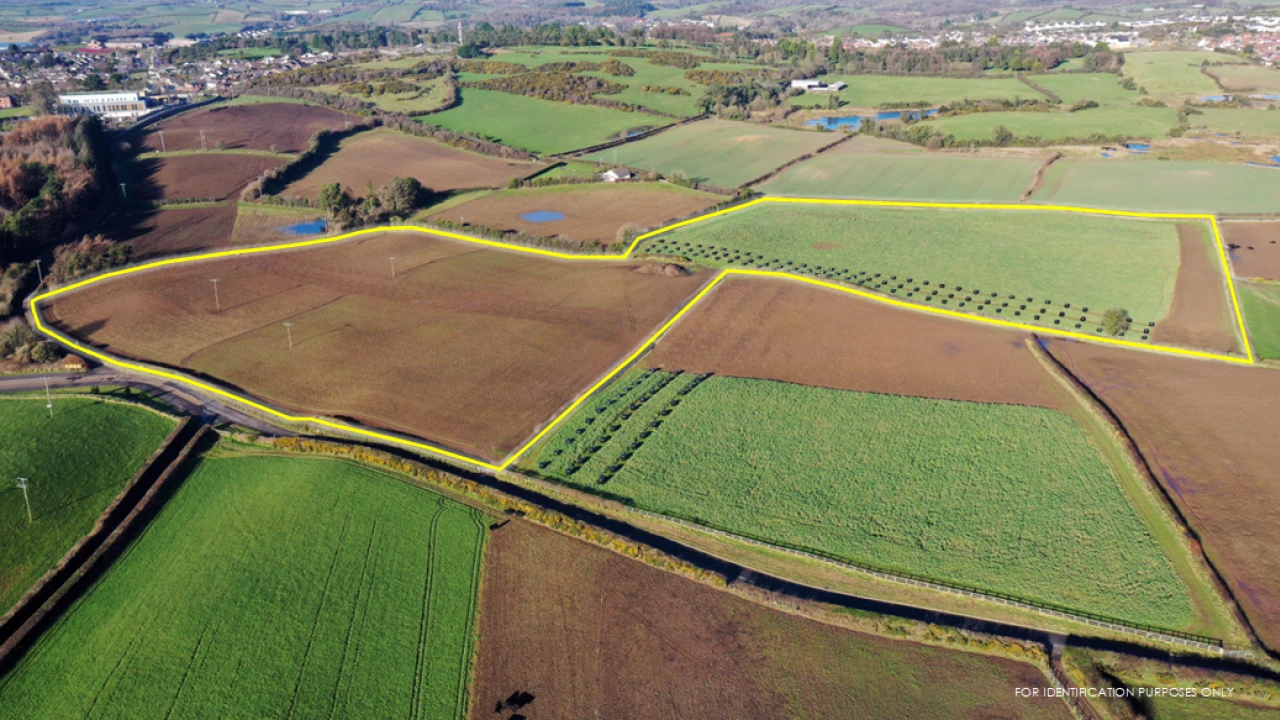
The subject lands extend to c. 16.4 acres and are arranged over two fields. The lands are currently in agricultural use and have an undulating topography.
Field boundaries are established by mature hedgerows having good frontage onto both the Ballyhornan Road and Struell Wells Road.
| PRICE: | Inviting offers in the region of £495,000 |
| TITLE: | Assumed freehold |
Planning
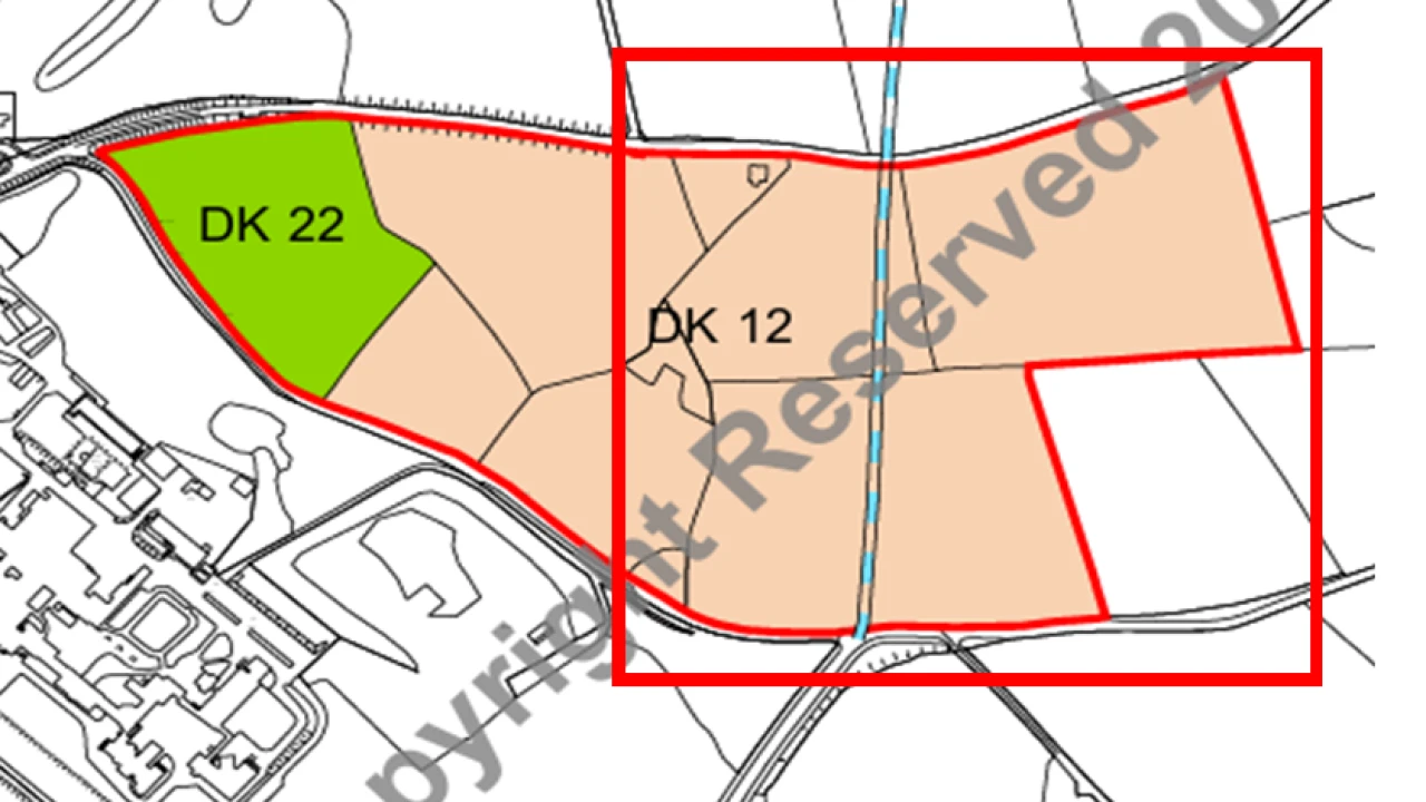
From a review of the Ards & Down 2015 Area Plan the subject appears to form a tranche of land zoned for Phase 2 Housing. The lands in the Area Plan are designated as DK12 and form part of 13.03 ha of land between Ballyhornan Road and Struell Wells Road.
In accordance with the Area Plan the development of these lands is reliant upon the provision of the Downpatrick Link Road. Any development on the lands will only be permitted in accordance with an agreed scheme to provide the necessary public infrastructure including roads and that said roads are to be designed to achieve maximum possible degree of integration in the landscape.
The Area Plan also details additional key site considerations, some of which are as follows:
Any housing development to be a minimum gross site density of 20 dwellings and a maximum of 23 dwellings per ha.
Phasing of any development in relation to infrastructural works
The proposed link road is to develop a bypass on the eastern fringe of the town between the A25 Strangford Road to the B1 Ardglass Road.
A portion of the proposed road appears to already have been constructed and the proposed route will dissect a portion of the subject lands.
The subject lands are located adjacent to a proposed large scale mixed-use development comprising 1,100 dwellings, retail units, community facilities, and a primary school (planning reference LA07/2025/0124/O).
VAT
All prices, outgoings etc are exclusive of, but may be subject to VAT.
Lands at Ballyhornan Road & Struell Wells Road, Downpatrick, BT30 6RJ
Belfast
c. 22 miles
Newcastle
c. 12 miles
Downpatrick is a popular provincial town in County Down and is situated c. 22 miles south of Belfast and c. 12 miles from Newcastle. Downpatrick lies within the Newry, Mourne & Down District Council Area and is one of the areas principle settlements
Sales Details
| PRICE: | Inviting offers in the region of £495,000 |
| TITLE: | Assumed freehold |
Planning
From a review of the Ards & Down 2015 Area Plan the subject appears to form a tranche of land zoned for Phase 2 Housing. The lands in the Area Plan are designated as DK12 and form part of 13.03 ha of land between Ballyhornan Road and Struell Wells Road.
In accordance with the Area Plan the development of these lands is reliant upon the provision of the Downpatrick Link Road. Any development on the lands will only be permitted in accordance with an agreed scheme to provide the necessary public infrastructure including roads and that said roads are to be designed to achieve maximum possible degree of integration in the landscape.
The Area Plan also details additional key site considerations, some of which are as follows:
Any housing development to be a minimum gross site density of 20 dwellings and a maximum of 23 dwellings per ha.
Phasing of any development in relation to infrastructural works
The proposed link road is to develop a bypass on the eastern fringe of the town between the A25 Strangford Road to the B1 Ardglass Road.
A portion of the proposed road appears to already have been constructed and the proposed route will dissect a portion of the subject lands.
The subject lands are located adjacent to a proposed large scale mixed-use development comprising 1,100 dwellings, retail units, community facilities, and a primary school (planning reference LA07/2025/0124/O).
VAT
All prices, outgoings etc are exclusive of, but may be subject to VAT.


Lands at Ballyhornan Road & Struell Wells Road, Downpatrick, BT30 6RJ
Belfast
c. 22 miles
Newcastle
c. 12 miles
Downpatrick is a popular provincial town in County Down and is situated c. 22 miles south of Belfast and c. 12 miles from Newcastle. Downpatrick lies within the Newry, Mourne & Down District Council Area and is one of the areas principle settlements